A business decision is only as sound as the data on which it is based. Denver South continuously monitors transportation, utilities, facilities, and resident reactions to enable advanced analytics, informed decision-making, and better resource allocation. Sharing these insights is a solid start.
Have other questions? Call or email us any time.
(Last updated 8/25/2020)
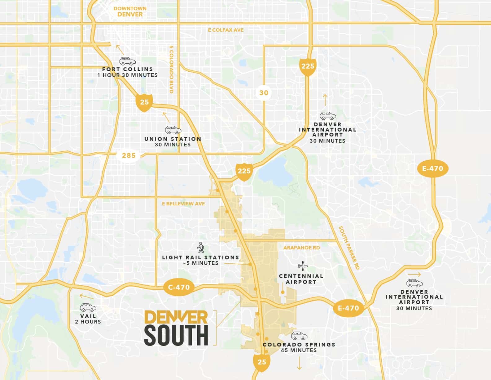
Local Travel
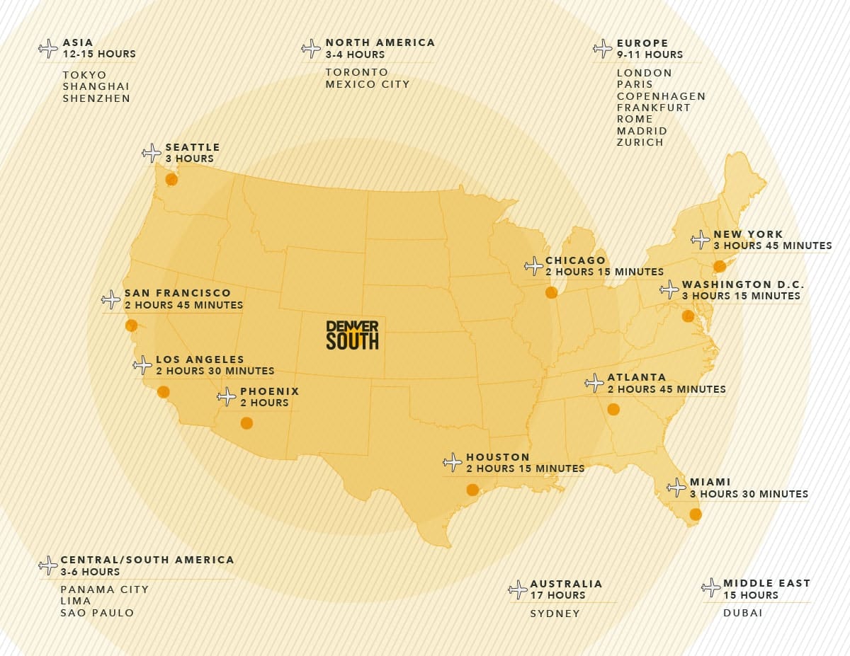
Domestic & International Travel
(Last updated 1/12/2022)
(Last updated 12/1/2023)
(Last updated 6/21/2024)
(Last updated 10/10/2023)
(Last updated 10/17/2023)
(Last updated 10/17/2023)
(Last updated 10/12/2022)
(Last updated 10/17/2023)
(Last updated 10/17/2023)
(Last updated 10/17/2023)
(Last updated 10/17/2023)
(Last updated 10/17/2023)
(Last updated 8/25/2020)
(Last updated 10/17/2023)
(Last updated 10/17/2023)
(Last updated 3/22/2023)
(Last updated 3/22/2023)
(Last updated 3/22/2023)
(Last updated 3/22/2023)
(Last updated 3/22/2023)
(Last updated 10/19/2023)
(Last updated 12/14/2022)
(Last updated 3/22/2023)
(Last updated 3/22/2023)
(Last updated 3/22/2023)
(Last updated 6/21/2024)
(Last updated 2/15/2021)
As a data-driven organization, Denver South consistently works to measure, manage, and improve mobility based on data. We work continuously with our jurisdictional partners to evaluate and integrate data to find new solutions and seize new opportunities. From Vehicle Miles Traveled (VMT) in the region, travel speeds on I-25 to complex survey data; Denver South is committed to using data to drive the work we do.
A few fun data points about transportation in Denver South:
- It’s a quick 30-minute drive from Denver South to Denver International Airport (airport code: DEN).
- DEN is among the best-connected airports in America with three-hour flights reaching anywhere in the continental US.
- Centennial Airport – located in the heart of the Denver South region – is the busiest corporate jet/general aviation airport in the country. This international facility features 24-hour US Customs and a 24/7 Federal Aviation Administration control tower, both with weather capability.
- Mass transit is a prized asset of Denver South. Nine light rail stops, numerous RTD bus routes, and inter-city Bustang service serve the region from Colorado Springs.
- The South I-25 Corridor between Denver South and downtown Denver sees over 200,000 vehicles per day, making it the highest volume section of roadway in Colorado.
- We’re a 20-minute drive from downtown and 60 minutes from the majestic, world famous Rocky Mountains.
- Three major off-street bike path and a network of on street cycling or walking options.
TomTom Data Partnership:
We’ve partnered with TomTom to use their MOVE tool to access real-time and historical traffic statistics to track impacts to the regional transportation network. This helps us with ongoing planning and investigating traffic incidents in real-time. With this unique insight, we can understand future commuting patterns and, in collaboration with our public sector partners, help design better systems over time.
on Public and Mass TransportationCommuting or not in
the time of coronavirus
(Last updated 3/14/2024)
(Last updated 2/21/2023)
(Last updated 3/4/2022)
(Last updated 2/23/2021)
(Last updated 8/25/2020)
(Last updated 3/27/2024)
(Last updated 3/27/2024)
(Last updated 8/10/2017)
Southeast Mobility Hubs Action Plan
(Last updated 3/2/2022)